.png)
Urban areas are characterized by the urban heat island effect. This phenomenon is caused by a change in the surface and differentiating surface properties and can be measured by both air temperature and surface temperature. The heat island effect results in high thermal stress for urban populations and is further exacerbated by global climate change. In 2003, for example, about 15,000 people in France and about 9,600 people in Germany died as a result of extreme heat events. A person's perception of heat and cold is individual and is influenced by the air temperature, wind speed, solar radiation and humidity in his or her environment.
Urban green infrastructure can influence these meteorological parameters in a local context and thus human thermal comfort at the small-scale microscale. For example, trees can reduce the surface temperature of sidewalks and streets through their shade and cool the air temperature through the evaporation of water on the leaf surface. An important task in the management of urban forests is to strengthen these services and maintain them in the future. In the subproject "GrüneLunge in the flow”", we therefore asked ourselves the following questions: Where do heat island effects show up in Karlsruhe and Rheinstetten? Where is the risk of exposure to the inhabitants the highest as a result? To what extent do trees change the small-scale climate in the city? Which tree species can have a particularly positive influence on the climate?
With the help of mobile measurements, we were able to determine the heat island effect in Karlsruhe along an urban-rural gradient of Karlsruhe and Rheinstetten in the project GrüneLunge 1.0. Afterwards, a neighborhood analysis was performed in which the collected data was linked to additional information such as land use data, information on building development as well as tree and tree species density over the immediate vicinity to the measurement route. Finally, a heat map of Karlsruhe was modeled which will serve as the basis for a detailed heat warning system in the future.
How we can localize heat threats in the city
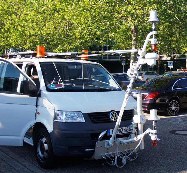
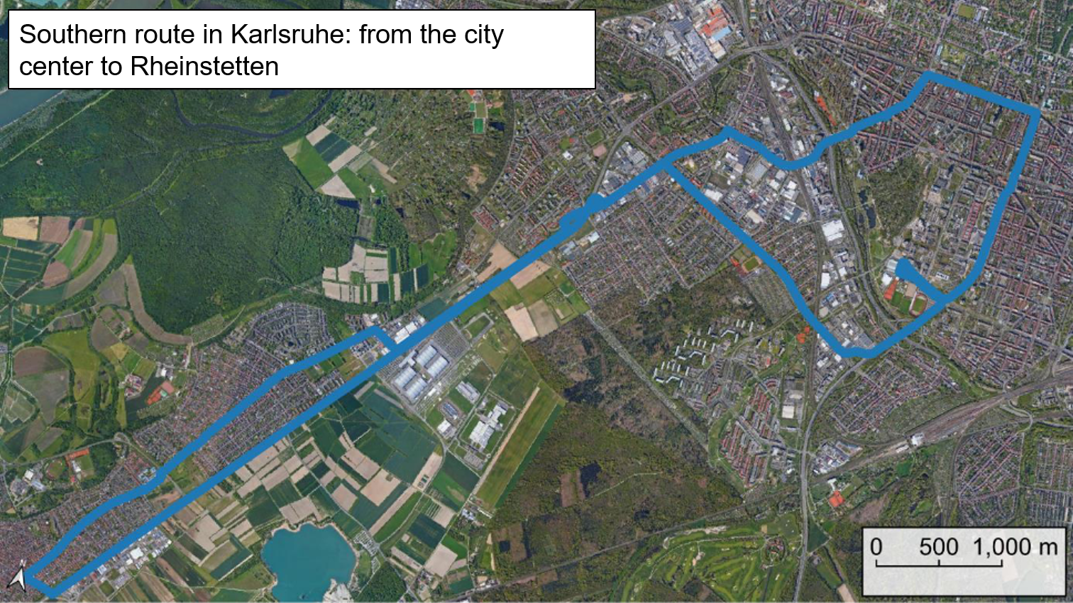
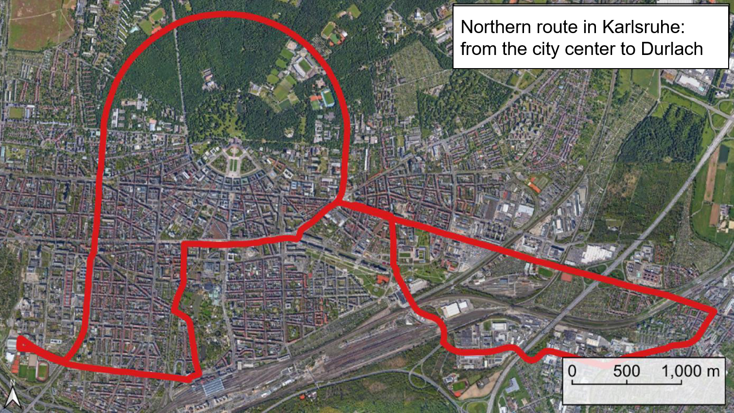
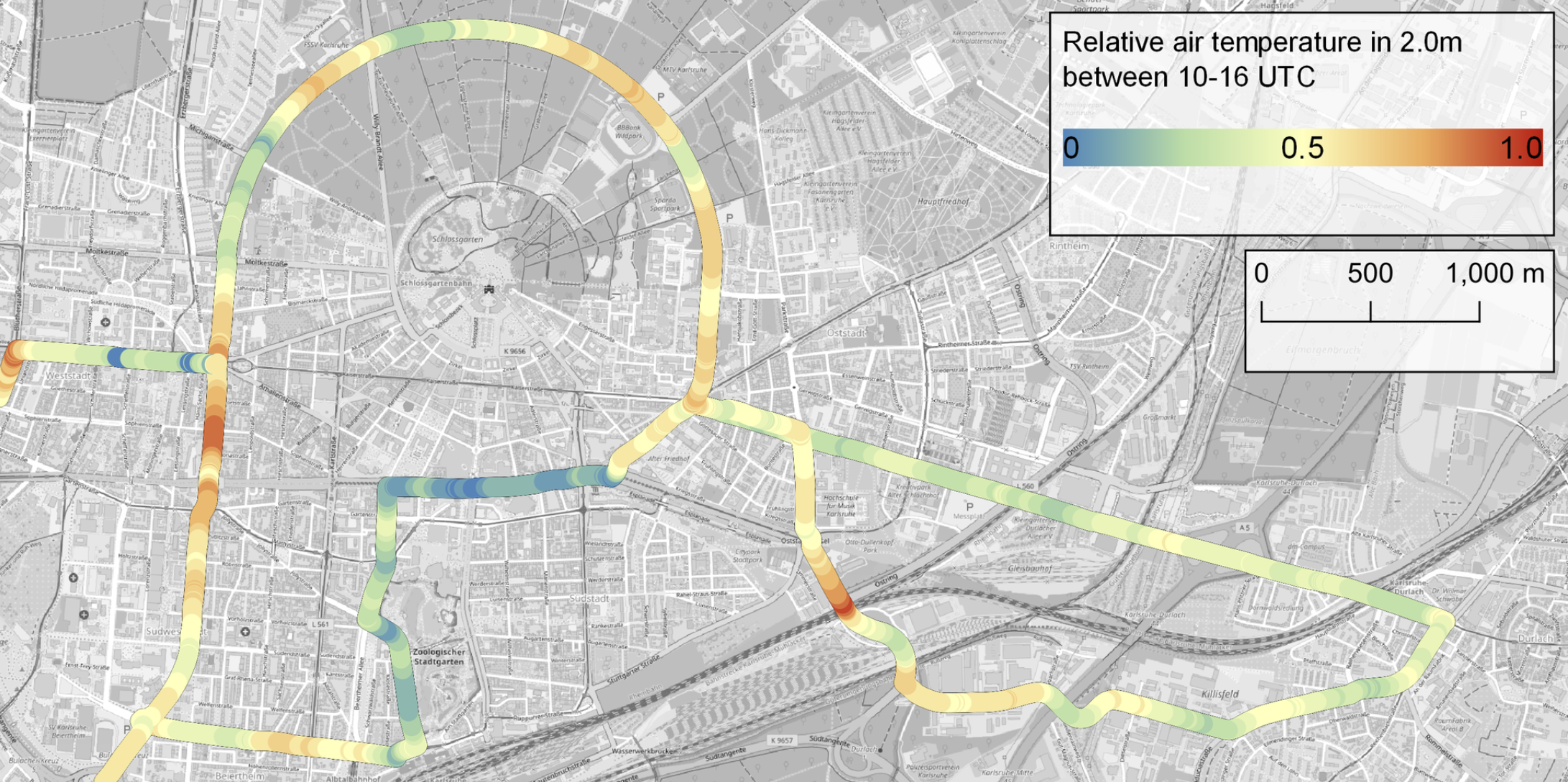
During the June heat waves in 2019 and 2020, we conducted mobile measurements with a measurement vehicle of the German Meteorological Service (DWD) (see figure on the left). The meteorological measurement system was installed at the front of the measurement vehicle and included measurements of air temperature, relative humidity, surface temperature, and global radiation (on the roof). The meteorological parameters were recorded every second while the measurement vehicle traveled on two routes (see figure below) through the project area.. In total, the northern and southern routes were each traveled 26 times. All measurement fdrives were conducted in three-hour intervals and the average trip duration was approximately 20 minutes, depending on the traffic situation.
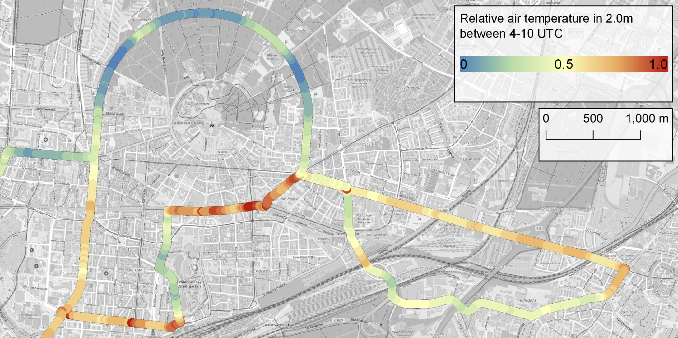
Municipal parks and zoological garden cool the city especially during the day
After the extensive processing of the measurements, the first observations on the urban heat island in Karlsruhe could be made. The relative air temperature at a height of 2.0 m above the ground is clearly dependent on the time of day and shows a very typical characteristic for urban heat islands. The urban heat island effect is most evident at night. The difference between relative air temperature in urban and rural areas shows here. In particular, the adjacent Hardtwald forest in the north is clearly the coolest. The influence of the Zoological City Garden is also weakly noticeableIn addition, a decreasing air temperature gradient can be seen between Karlsruhe city center and Karlsruhe Durlach in the east. A similar gradient is also visible between Karlsruhe city center and Rheinstetten. However, a small urban heat island is also pronounced by the urban structures in Rheinstetten itself.
The urban climate declines with increasing sealing
In the neighborhood analysis, the processed meteorological data was considered with different distances to the measurement route from 10 m to 500 m and the immediate surroundings were analyzed for built-up area, vegetation, tree species diversity, land use and sealing.
We found that a high degree of sealing in urban areas resulted in high values of relative normalized air temperature at 2.0 m, especially during the nighttime intervals 0 - 6 am and 6 - 24 pm. During the morning hours, areas with low levels of sealing were cooler than areas with high levels of sealing, and unsealed areas were always the coolest. This increase in relative air temperature from a low to a high degree of sealing was observed primarily in the evening hours. However, the effect may not be due to sealing alone, but rather due to the three-dimensional volume of the building mass. This is because the relative air temperature is also influenced by the building height in a similar way.
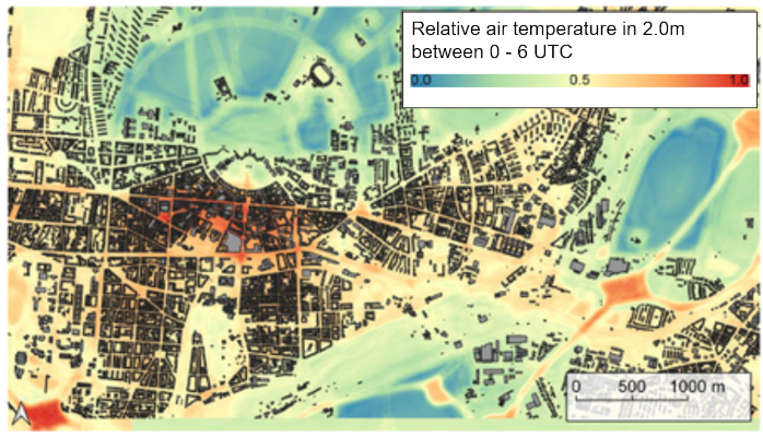
Based on the results, a heat map of Karlsruhe was modeled (see figure on the right). In the follow-up project GrüneLunge 2.0, thefindings about the heating within the city will be used to implement a local, specific heat warning system based on the DWD's National Warning System. The implementation of a specific heat warning system, based on the predicted relative air temperature, can be done for the complete Karlsruhe city area. This heat warning system should take into account risk and protection factors of the urban infrastructure, such as hospitals, retirement homes, nursing homes, schools and kindergartens. If successfully implemented, the proposed method also offers the potential for implementation in other German/European cities with comparable northern latitudes. More on the planned activities can be found here: Specific heat warning system.
Photos: Marcel Gangwisch/DWD